|
||||||
|
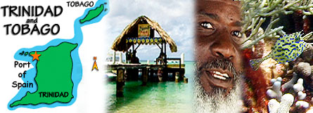
Helpful Information on Tobago |
|
||||||
|
Helpful Information on Tobago |
|
Tobago (to-bay-go). The Island that inspired Robinson Crusoe, 25 miles long and 8 miles wide is located just of the Venezuela coast, and together with it's larger sister Trinidad are the southern most of the Caribbean Islands and split the Atlantic and Caribbean Latitude: 11 N, Longitude 60 W Physical Area: Fish-shaped, measures 26 miles, 42 km, by 7 miles, 10 km. Total Area: 116m, 300km. Major Towns: Scarborough, Roxborough, and Charlotteville. |
 |
|
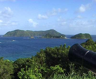
This view is from the mainland looking over Goat Island towards Little Tobago |
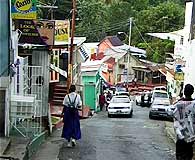 |
Tobago is just 32km, 20m, off the northeast coast of Trinidad. Tobago has a central hilly range with a flat area in the south and west of the island where much of the tourism has developed. This area, influenced by the presence of fringing offshore reefs, has distinct beaches with soft powdery white or cinnamon brown sand. Commercially, the island was noted for the production of sugar, cocoa, coffee and citrus products at various times in the past. Scarborough street scene |
|
Tobago has been fought over by British, French and other colonial powers, changing hands at least 25 times. These colonial settlers have left their mark on Tobago's past by way of the various place names such as Glamorgan and L'Anse Fourmi and ruins of forts and sugar mills and water wheels scattered around the Island. ( Anse in French means beach). |
|
Scarborough (the capitol city) |
 |
 |
The Botanic Gardens separates Upper Scarborough from Lower Scarborough, and was built in 1888. The Gardens with its many exotic plants and shrubs is well worth a visit. |
 |
|
Lower Scarborough runs along the Atlantic Ocean, which crashes against this shore with vigour and energy, much like the people who inhabit the town. The main feature of Lower Scarborough is the local market, with stalls and produce ranging from flowering plants, to fruits and vegetables. Nearby are stores, banks, the Scarborough library and the Tourism Information centre in the NIB Mall. Area: Trinidad 4,828 sq. km (1,864 sq. miles); Tobago 300 sq. km. (116 sq. miles) Population: 1.3 million (Tobago 50,000), tracing their roots back to Africa (40%), India (40%), Europe, the Mediterranean, the Middle East and China. Most major religions are represented, including Christianity (Roman Catholic 29%, Anglican 11%, Presbyterian, Methodist and evangelical faiths), Hinduism (24%), Islam (6%) and traditional African faiths Language: The official language is English; the old French-based patois has almost died out, and some Hindi is used in the Indian community |
 |
 |
|
 |
 |
|
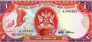
Money: The Trinidad and Tobago dollar (TT$) floats against the US dollar and other currencies; daily exchange rates are carried in the press. Credit cards are widely used in tourist areas, and by car rental companies, hotels and restaurants. Leading banks offer ATM machines which accept international cards Time zone: 1 hour ahead of Eastern Standard Time, 4 hours behind Greenwich Mean Time Climate: Average temperature 29°C (83°F), with a maximum daily temperature in the low to mid 30s. June to December are the wettest months, with rainfall mostly in short sharp bursts; Tobago is often slightly cooler and less humid than Trinidad Phone codes: Country code: 868 (prefix to all numbers when calling from another country) Geography Trinidad and Tobago are the southernmost islands in the Caribbean chain, only 10km (7 miles) from the Venezuelan coast and geologically part of South America. The two islands are 33km (21 miles) apart. Trinidad is half forested, with a range of low mountains running along the north coast (the highest point is 940 metres, 3,085 ft.); there is a flat central plain, with rolling hills in the south. Tobago has a central spine of hills rising to 549 metres (1,860 ft.), with flatter land in the south. The national capital is Port of Spain (pop. 350,000); Tobago's capital is Scarborough. Other major urban areas in Trinidad are San Fernando in the south, Chaguanas (central) and Arima (east) Tobago is a stunningly beautiful tropical island just 26 miles long and 8 miles wide (42 by 10 kilometres) and 10 degrees north of the equator, with a rugged, craggy coastline, deserted palm-fringed beaches, enchanting coral reefs and a wealth of protected rainforest. With no heavy industry, very light development and only a handful of all-inclusive resorts, Tobago has remained exceptionally natural and unspoilt. Tobagonians are deeply religious, have pride in their culture and heritage and are extremely friendly and welcoming, making Tobago a very safe island to explore. The most developed areas of Tobago are in the Lowlands - the coral and limestone plateau of the southwest. Situated in this region are Crown Point International Airport, a few smart hotels along the Caribbean coast, Buccoo Reef, the fine white sandy beaches of Pigeon Point and Store Bay, and Scarborough – the colourful and picturesque capital and port. Tobago’s windward (south) coast, pounded by the powerful, white-capped waves of the Atlantic Ocean, is dotted with charming fishing villages. Speyside and Charlotteville, lying at the most easterly tip of the island, have impressive coral reefs - many within swimming distance of the beach - ideal for scuba diving and snorkelling. The leeward (north) Caribbean coast has an array of beautiful coral sand beaches such as Castara, Englishman’s Bay, Parlatuvier and Bloody Bay which are deserted, except for a few fishermen. The landscape of the eastern interior rises steeply into the hills which comprise the central Main Ridge. These rocky elevations shelter the rainforest which falls sharply away to the palm-fringed, sandy beaches below. Dripping with moisture and shrouded in mist, the rainforest is a veritable paradise for naturalists and birdwatchers. Little Tobago – about 3 miles (5km) out to sea and just 1 mile (1½ km) long at its widest point - is a solitary, uninhabited seabird sanctuary off Speyside. Local fishermen will be happy to take visitors to see the island with its resident frigate birds, terns, boobies and the red-billed tropic bird. |
|
Accommodation ~ Activities ~ Beaches ~ Calendar ~ Diving ~ Ecology ~ Exploring ~ Fun Facts |
|
This website designed & hosted
by |